|
John L's Old Maps / Supplementary Pages: ReferencesWith a little literature review and history –
|
|
Cartography in General
|
Hayward, Wisconsin History
|
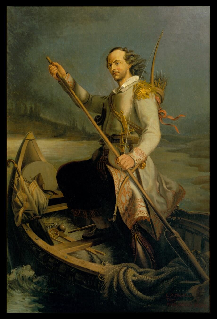
 Click on the image on the right for a full view of the portrait of Beltrami by Gian Antonio Micheli, reproduced on this site with permission of the Minnesota Historical Society.
|
|
Jean-Nicolas Nicollet (also known as Joseph N. Nicollet) made note of five creeks that entered Lake Itasca, and found most impressive the one that has since been named for him. In his Report to both houses of Congress (published in 1843 and 1845; both editions cited below), he wrote extensively of the stream, its associated lakes, and the overall basin whose contributing streams poured out of the surrounding hills. To the east of his creek, he noted on his map a representation of the sizable lake (presently called Elk Lake) which empties into Lake Itasca through a very short stream (presently called Chambers Creek), but there are no such details in the text of the Report. Lest it be thought that Nicollet passed over the lake and its feeders entirely and relied on local information for his map – and/or considered Elk Lake to be just a bay of Lake Itasca and not worth any special mention – one will find his descriptions of Elk Lake (and its inlets and outlet) plainly discussed in his more extensive Journals which were finally published in 1970 (cited below). As opposed to the Schoolcraft-Allen Expedition, Nicollet spent three days (at the end of August, 1836) in the Lake Itasca area. Probably not realizing the aforementioned tight schedule the Schoolcraft-Allen Expedition was on, Nicollet had already criticized Allen (in his Journal, Aug. 5) for occasional carelessness in mapmaking, stating "...good science cannot be accomplished by traveling a hundred miles a day. Why go to the trouble of mustering a national expedition and end up throwing confusion over the work done by the brave Major Pike thirty years earlier?"
Backing up to 1805, U.S. military officer Lt. Zebulon Pike was ordered to find the source of the Mississippi River, but he became detoured onto Leech Lake. His findings were published in a volume (in the list below) heavily edited by Elliot Coues whose essay-length footnotes clarified Pike's role in the proper context of discovery. Coues gives great credit to the work of others who came later – including the aforementioned Allen and Nicollet – and shows great respect for the contribution of Beltrami. As do a few other authors and explorers, Coues refers to William Morrison, a very early (non-French) fur trader and occasional resident near Lac La Biche at the beginning of the 19th century. Check out this interesting article relating to Pike's legacy.
Recall from above that Itasca and Elk Lakes (as they are now known) had been respectively called Elk Lake (French: "Lac La Biche") and Pokegama Lake by the natives whose ancestors were of course the actual discoverers of any and all of the natural features in the area. It was left to Julius Chambers in 1872 to make a more public mention of Elk (the former Pokegama) Lake and its tributaries. Whether Elk Lake was ever a bay of Lake Itasca was a matter of debate among writers of the 19th Century. In his 1893 volume (referenced below), Brower gives some credence to that view, stating: "In the summer of 1890, after copious rainfall, Lake Itasca rose a foot or more above Elk lake, and Chambers creek flowed into instead of out from it, a certain indication that Itasca lake draws its principal supply from beyond the narrow limits of Elk Lake."
Establishing the beginning of the longest continuous open-water course of water that continues into the Mississippi River (which begins to act like a coherent river at the mouth of Lake Itasca) was apparently accomplished by the detailed and scientific explorations of J. V. Brower. His originating streams are (1) a tributary of Nicollet Creek (i.e., Howard Creek) which eventually flows into the southwest arm of Lake Itasca and (2) Mary Creek which flows through an extended valley and Mary Lake and eventually empties into the eastern arm. It appears that the Nicollet Creek system (with Howard Creek) has the edge. Most importantly, it was determined in his studies that the inlet bearing the greatest volume of water entering Lake Itasca is Nicollet Creek, beating out Chambers Creek which connects with Elk Lake. Indeed, Nicollet had called his creek "the infant Mississippi" and "a cradled Hercules" in his Report.
The Microsoft Research Maps (MSR, formerly Terraserver-USA) site showed black-and-white aerial photos of the Itasca Basin (and everywhere else) in stunning detail – more so than in the color photos available now. I managed to copy some of these maps to my Mississippi River pages (sometimes with additional embellishments) before the MSR resource was unreasonably taken off the web. An example showing the source of Howard Creek is shown here under "Still More Geography." (Be sure to click on it for the enlargement.) As another example of a MSR aerial photo, one which features Lake Itasca (with its three "arms") is shown here along with Elk Lake (lower left, taking up most of a square mile) and Mary Lake (lower right); unfortunately I didn't keep a larger, more-detailed photo. (And remember that the direction of the current is from south to north; i.e., bottom to top.)
- - - - - - - - - - - - -
The references in the following list are arranged chronologically according to the sequence of the explorations – not according to publication date. One can utilize a search engine to find copies of any of them on the web, but nothing beats an authentic hard copy. Nicollet's Report and Journals include his Mississippi and St. Croix/Brule explorations of 1836 and 1837, respectively. Willard Glazier was to receive condemnation for rampant falsification of information, and it was his notoriety that instigated the thorough researches of Clarke and Brower who each include in their reports a denouncement of Glazier's falsehoods and an examination of Nicollet's three lakes and associated creeks and springs. Furthermore, Chambers had indeed preceded Glazier in visiting the Itasca basin, and he published his accurate results in newspaper articles (not yet cited below, but noted in other references nonetheless) in the 1870s.
On page 15 of this official document of the Minnesota State Legislature is an accounting of the ignominiac Willard Glazier's selective plagiarism in order to give himself credit for discovering and naming (with his name to supercede that of Elk Lake) the source of the Mississippi River upstream of Lake Itasca. As stated in this document, the Legislature passed a law in 1889 "forbidding any school from using a geography text with Glazier's historical version of the headwaters."
|
To counter an argument that a tributary of Elk Lake – i.e., Elk Creek – should be considered the ultimate, continuous, open-water source of the Mississippi, Brower (1893, p. 260) remarked how much he saw it dried up in August, 1889 such that it could only be considered an intermittant stream. Elk Creek is shown as such on a topographical map on the Microsoft Research Maps site where its origin appears as "Elk Pool," about the same latitude as Whipple Lake. |
Clarke and (especially) Brower – and also Chambers who subsequently went along with Brower's arguments – apparently got confused about Nicollet's descriptions and locations of his three lakes. Instigating this confusion was their insistance that Nicollet was writing about tracing the course of his three lakes while going upstream, while Nicollet made clear (especially in his Journals) that, while keeping the course of his stream in view, he took a hike some miles away from Lake Itasca and then looped back, closely following his creek and three lakes downstream. Furthermore, the editor of Nicollet's Journals recognizes Whipple Lake as Nicollet's upper lake.
- Pike, Zebulon M. and Elliot Coues (ed.). 2015. The Expeditions of Zebulon Montgomery Pike to Headwaters of the Mississippi River, through Louisiana Territory, and in New Spain, During the Years 1805-6-7 – Vol. 1 of 3. Forgotten Books, FB & c Limited, London.
- Nicollet, J. N. 1843. Report Intended to Illustrate a Map of the Hydrographical Basin of the Upper Mississippi River. (26th Cong., 2nd sess., Senate Document 237.) Blair and Rives, Washington, D.C. This report accompanies Nicollet's map (published in 1843), and the map and Report were reissued in 1845 for the House (see next in list). The Senate Document can be read in its original form (without the map) here.
- Nicollet, J. N. 1845. Report Intended to Illustrate a Map of the Hydrographical Basin of the Upper Mississippi River. (28th Cong., 2nd sess., House of Representatives Document 52.) Blair and Rives, Washington, D.C.
- Bray, Martha Coleman (ed.). 1970. The Journals of Joseph N. Nicollet. Minnesota Historical Society, St. Paul.
- (An analysis by a very amateur historian/geographer of Nicollet's observations in the valley of his "Infant Mississippi" – with a side-by-side comparison between his Journal and Official Report – is here.)
- Chambers, Julius. 1910. The Mississippi River and its Wonderful Valley. The Knickerbocker Press, New York.
- Glazier, Williard. 1894. Headwaters of the Mississippi. Rand, McNally & Co., Chicago and New York. Reprinted by the University of Michigan University Library.
- Various authors including Hopewell Clarke. 1887. [Full title:] The Source of the Mississippi Comprising I. Letter from Messrs. Ivison, Blakeman, Taylor, & Company; II. Report of Hopewell Clarke, Chief of the I. B. T. & Co. Expedition to the Headwaters of the Mississippi, October 1886. Ivison, Blakeman, Taylor & Co., New York & Chicago. This is a reprint of an article in Science (Dec. 24, 1886) and can be read here.
- Brower, J. V. 1891. The Source of the Mississippi River. The Journal of the Manchester Geographical Society, Vol. VII, pp. 301-310.
- Brower, J. V. 1893. The Mississippi River and its Source. Harrison & Smith, State Printers, Minneapolis. This is Volume 7 of the official Minnesota Historical Collections. A reprint by the University of Michigan University Library left out a key map whose page is reproduced here.
- (Brower was soon to embark on an expedition to find the ultimate source of the Missouri River. See the next section, below.)
- Brower, J. V. 1904. Itasca State Park – An Illustrated History. McGill-Warner Company, St. Paul. This is Volume 11 of the official Minnesota Historical Collections.
- (An analysis by the aforementioned parenthetical amateur listed above seeks to relate present-day observations of the Nicollet Creek system to those of Clarke and Brower. Click here and scroll way down.)
Following are some excellent and classic summaries of the explorations of the Itasca Basin through Brower. Much of this material is a refutation of Glazier's misrepresentations. As long as the Itasca State Park persists in the display of Glazier as glorious antihero and ignores such notable explorers as Lt. Allen, these references add a much-needed substance to the show. Coues (editor of the Pike journals – see above) adds notes from his own explorations.
- Hurlbut, George C. 1891. The Pretended Discovery of the Source of the Mississippi River by Capt. Willard Glazier. Journal of the American Geographical Society of New York, Vol. 23, pp. 378-385. Included is a large fold-out of Brower's detailed hydrographic map, dated 1891.
- Coues, Elliot. 1897. Historico-Geographical Notes on the Mississippi River, from Cass Lake to Lake Itasca. Annals of Iowa, Vol. 10, pp. 20-31. This is a summary of the explorations of the area with additional observations and learned opinions of the author. Each page is reproduced here.
- Levasseur, E. 1898. The Question of the Sources of the Mississippi River. Collections of the Minnesota Historical Society, Vol. VIII, pp. 213-225.
- Winchell, N. H. 1898. The Source of the Mississippi. Collections of the Minnesota Historical Society, Vol. VIII, pp. 226-231.
Lewis & Clark and Brower on the Ultimate Source of the Missouri River
In their quest to maintain as westerly an expedition as possible from the "three forks" of the Missouri River, the Lewis and Clark Expedition headed up the Jefferson and Beaverhead Rivers and then up Horse Prairie Creek – one of the two ultimate forks of the Beaverhead. (The easterly/southerly fork was called "Red Rock Creek" and is today known as Red Rock River whose upper tributary has kept the "Creek" designation as indicated below.) From Horse Prairie Creek, they came to a withering side branch, Trail Creek, whose source was very near Lemhi Pass at the Continental Divide. Passing those, they made themselves certain in August, 1805 of at least four things: (1) They had discovered the source of the Missouri; (2) they were over the Divide (then the western boundary of the U.S.); (3) commerce would find no navigable "Northwest Passage" through the continent; but still (4) it had to be all downstream from there to the Pacific Ocean even though they could see nothing but mountain ranges toward the west. Shown on page 99 in the Salisbury volume listed below (which contains almost 200 black-and-white photos and drawings) are how the westerly and easterly views from Lemhi Pass appear to the modern-day visitor.
|
|

Having myself traveled many hours through unpaved roads of southern Montana in 2016-17, I came up with the following thought: It would be a moot point to determine if the Lewis and Clark Expedition would have had an easier time – in crossing mountain ranges, portaging, and navigating streams – by taking the southeast fork of the Beaverhead River instead of going west with Horse Prairie Creek. In doing that, they would have gone up the Red Rock River/Creek and crossed the Divide near tributaries of the Snake River which would have taken them west again. If they had actually gone that way, they probably would have discovered a more significant extension of the Missouri River.
Ninety years after Lewis and Clark discovered the western source of the Missouri River and soon after J. V. Brower completed his explorations of the Itasca Basin (above section), Brower went on to trace the southern and ultimate source of the Missouri River which he found in Culver's Canyon (also known as Hell Roaring Canyon) in the Centennial Mountains on August 28, 1895. This is in far southern Montana, about 19 miles WSW of West Yellowstone, MT. No photo was published of the site (perhaps none were taken), but thankfully an August, 2005 photo of "Brower's Spring" can be found on the web here.
From the source and going downstream, the water from Brower's Spring flows successively into Hell Roaring Creek, Red Rock Creek, the Upper and Lower Red Rock Lakes, Red Rock River, Clark Canyon Reservoir (which is flooded over the aforementioned junction of the Red Rock and Horse Prairie streams), Beaverhead River and then the Jefferson River. The Jefferson and Madison Rivers join to form the Missouri which is soon to take in the Gallatin River; such is the situation at the "three forks" of the Missouri. This entire route can be visualized with a map such as the road atlas which is referenced below with additional comments. Backing up a bit: As the Red Rock River flows through the Centennial Valley in a westerly direction, it and the successive streams join to make a broad, clockwise turn – with the Missouri River heading out of Montana in an easterly direction, continuing this trend in a very general way as it joins the Mississippi which heads south to the Gulf of Mexico. This is not unlike the Mississippi River itself which starts out by flowing north from the Itasca basin, eventually making its clockwise turn (on a much smaller scale) toward the east and south to the Gulf.
In his 1897 publication of this discovery (below), Brower expressed regret that the name "Mississippi River" was applied to the entire stream from the Itasca Basin to the Gulf of Mexico. He states the following about the naming of the rivers and the view of the Missouri by explorers and settlers of European origin: "Had the discovery of this principal and chief river channel proceeded from the West toward the East, there would have been but one name for its entire course from the continental divide [Brower's Spring] to the Gulf of Mexico, and the mouth of the Mississippi would be where is now the mouth of the Missouri."
- Salisbury, Albert and Jane Salisbury. 1990. Lewis and Clark – The Journey West. Promontory Press, New York. In this book, the Lewis and Clark trails are shown along with highways (circa 1950 which would appear appropriate for the writing and photographs) and directions for reaching the key points in the Expedition. Dozens of photographs and drawings depict natives, scenes, activities and animals along the way. I consider the next book (with the DVD) in this list to be the companion volume to this work.
- Duncon, Dayton and Ken Burns. 1997. Lewis & Clark, The Journey of the Corps of Discovery – An Illustrated History. Alfred A. Knopf, New York. This book goes along with Ken Burns's PBS documentary film, "Lewis & Clark, The Journey of the Corps of Discovery" which continues to be available on DVD.
- Brower, J. V. 1897. The Missouri River and its Utmost Source. The Pioneer Press, St. Paul.
- Benchmark Maps. 2015. Montana Road and Recreation Atlas. Benchmark Maps, 120 Cremona Drive, Suite H, Santa Barbara, CA 93117. This atlas shows the above-named streams and also labels "Source of the Missouri River (Brower's Spring)" at a clearly-defined location.
If one is unable to hike or take a horse-ride to this spot, Hell Roaring Creek is at least crossed by and viewable from the unpaved road which passes through the general area between Monida and Henry Lake. (Note my photo above.) It should be mentioned that various names have been applied (in maps and on-site) to this road including "South Valley Road" and "Highway 509" in Montana, and "Red Rock Pass Road" in Idaho. The Benchmark Maps road atlas extends the name "Red Rock Pass Road" westward from Idaho to Monida.
How Rivers Should be Named
In several of the references on this page (starting with Beltrami, 1828), mention is made of naming conventions and how names should be applied to the main streams and their major tributaries. What should decide which stream's name should trump the other below their junction? Length, width, volume, the angle at which they meet, and the overall directional trend are a few of the considerations posed which would be more scientific than putting emphasis on tradition and the sequence of discovery.
The Missouri River is the longest branch of the Mississippi. Perhaps the ideal situation would be to have a completely new name for the stream thus formed; likewise, the river from the junction with the Ohio (the most voluminous branch) to the Gulf would also have its own name. For what has been traditionally called the Mississippi River, the three main divisions are designated Upper, Middle, and Lower; this naming convention appears to suffice for the present as indicated here. (Consider the supplemental diagram here.) Furthermore, the Mississippi River appears to keep its "directional integrity" at the junction with the Missouri as seen here, and determination of which of the two comes through with a higher volume at that point is not fixed on either one of the rivers as noted here.
A valuable, contemporary discussion of this topic which includes the points presented above is found here. Also take a look at the "Discovering Lewis & Clark" site for more historical perspectives.
But, what about geological history as a factor in naming rivers, or (at least) in determining whether or not a tributary (however obscure presently) should be seriously considered as the ultimate source? A 2012 essay by Wendell Duffield which was published in the Minneapolis Star Tribune suggests the Little Minnesota River as the ultimate source stream of the Mississippi River. It presently originates in northeastern South Dakota and follows the deep channel of the ancient River Warren as it flows into the Minnesota River, presently a major tributary of the Mississippi. In ancient times, the Mississippi above that point was a relative trickle as it flowed into the Warren which carried meltwater from a receding glacier to the north. (I won't give away anything more about this interesting article.)
More on the St. Croix and Brule River Area
The references given above relating to the Schoolcraft-Allen Expedition of 1832 and also to Nicollet's Journals and Report contain extensive notes concerning the state of these rivers and the intervening portage in the 1830s.
The following three books give interesting historical and contemporary information about the St. Croix and Brule Rivers and include stories of noted individuals who utilized the portage over the years – including Daniel Graysolon du Lhut who cut trees and broke dozens of beaver dams as he charged up the Brule in 1680, and Lt. James Allen in 1832 who was the first to record the presence of brook trout on the Brule. The Marshall book discusses the proposed Lake Superior to Mississippi River canal which is mentioned on this site here. A web page on the subject with a map can be found here. Ross summarizes the evolution of the Great Lakes as they emerge from the retreating glacier, indicating the St. Croix River as a major outlet during the Lake Duluth Stage – a little more of which is discussed here. Ross also provides a close-up map of the St. Croix-Brule portage area, but the major theme of his book concerns historical and geographical details about the Apostle Islands.
- Dunn, James T. 1993. The St. Croix: Midwest Border River. Holt, Rinehart and Winston, New York.
- Marshall, Albert M. 1954. Brule Country. North Central Publishing Company, St. Paul, MN.
- Ross, Hamilton N. 2000. La Pointe: Village Outpost on Madeline Island. State Historical Society of Wisconsin, Madison. Originally published in 1960 by North Central Pub., St. Paul.
Here is an excellent overview of the geography and history of the Brule region with lots of illustrations, chronological lists, and directions where one can drive and/or walk through the area and see where people lived and traveled so many years ago:
- Wisherd, Nan. 2005. Pathways – The Earliest History of Northern Wisconsin's Brule Region. Waino Publishing, Brule, WI.
The Apostle Islands
For the Apostle Islands, these references (in addition to Ross and the 1855 Schoolcraft volume, above) are also noted on the Apostle Islands pages (here & here) and the Steamboat Island page:
- Nelson, Charles R. 2001. On Thin Ice – Windsleds at Madeline Island. This is available from the Windsled Museum website.
- Nuhfer, Edward B. 2004. A Guidebook to the Geology of Lake Superior's National Lakeshore. Eastern National, Fort Washington, PA. Book includes poetry by Mary P. Dalles.
- Strzok, Dave. 2003. The Visitor's Guide to Apostle Islands National Lakeshore. This is available at the Keeper of the Light in Bayfield, WI.
- Turner, J. M. 1888 & 1890. Lake Superior Region. W. E. Prudhomme, Ashland, WI. Turner only takes credit for being editor and illustrator. Book at first glance appears to be overwhelmingly full of blank pages. However, the text is printed on one side of the page; the accompanying illustrations are likewise, but are facing the text with the insertion of a tissue sheet to protect the images. Amazing photos and insights. A 19th-century coffee-table book of genuine substance.
Evolution of the Northwest Territory
The following contain valuable information regarding the evolution of territories, states and counties from the old Northwest Territory. The volumes edited by Long (part of a series intended to cover the entire U.S.) trace the entire history of county boundaries in detail and include interesting details about counties "attached" to other counties for judicial and other purposes as they become fully "organized" and eventually "independant." A brief history of county creation in Michigan is given here.
- Wisconsin Highway Planning Survey (ed.). 1947. A History of Wisconsin Highway Development, 1835-1945. Official state publication, Madison, WI.
- Thorndale, W. and W. Dollarhide. 1987. Map Guide to the U.S. Federal Censuses, 1790-1920. Geneological Publishing Co., Inc., Baltimore, MD.
- Long, J. H. (ed.). 1997. Michigan – Atlas of Historical County Boundaries. Charles Scribner's Sons, New York.
- Long, J. H. (ed.). 1997. Wisconsin – Atlas of Historical County Boundaries. Charles Scribner's Sons, New York.
- Long, J. H. (ed.). 2000. Minnesota – Atlas of Historical County Boundaries. Charles Scribner's Sons, New York.
- Lanegran, D. A. 2008. Minnesota on the Map: A Historical Atlas. Minnesota Historical Society Press, St. Paul, MN.
|
E-mail me at: |
This page was last modified on 11/6/17 at 1:45 PM, CST. John Lindquist: homepage, complete site outline. Essays which form a part of this literature review are copyrighted. Photos on jlindquist.com are by myself unless otherwise noted. And if I could do it all over again, I probably would pass on the Microbiology program in order to take up Geomorphology and Surveying, and thus be a happy camper and get out more. |