|
John L's Old Maps / Special Pages: Steamboat Island
|
|
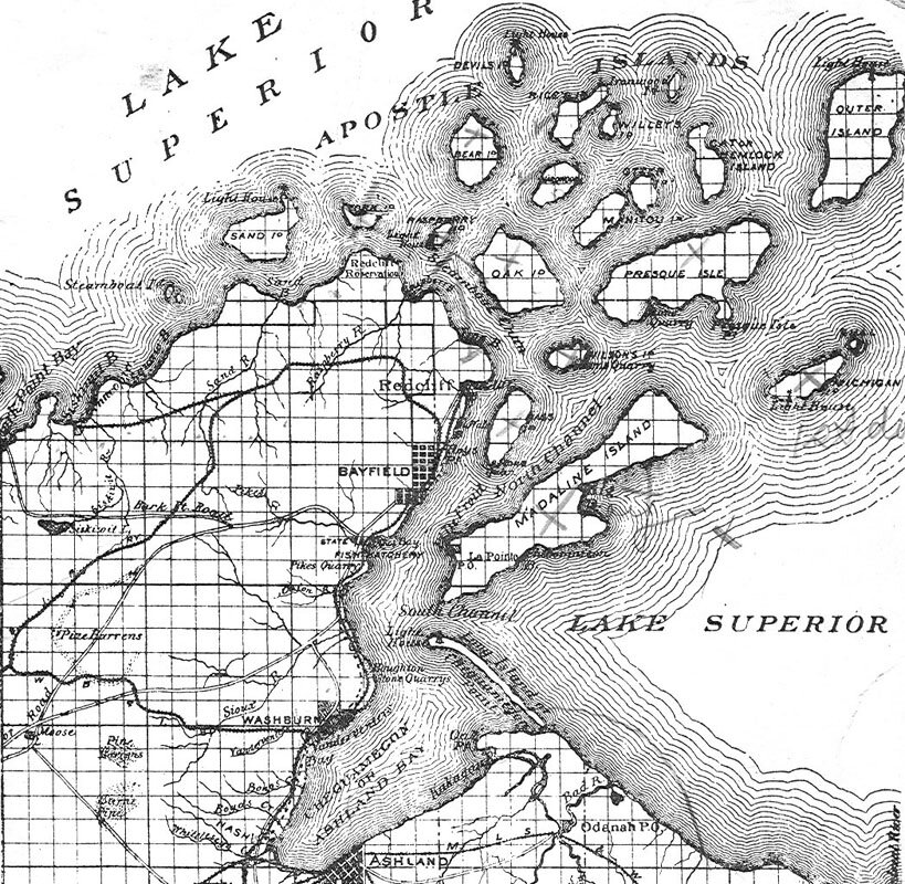
Steamboat Island – the legendary submerged member of the Apostle Islands which was destroyed in a storm in 1901 – fell into historical obscurity over the past century. Slowly but surely it is re-emerging on the web as an increasing number of relevant historical documents are being uploaded from diverse sources. Through much of the nineteenth century, what is now known as Eagle Island was popularly called Steamboat Island, while the subject of this web page – just a short distance to the south – was distinguished on many maps as Little Steamboat Island. More about these names is given here. An examination of the Wisconsin Public Lands Survey Records site reveals original survey notes and maps. One can click on the map on the Bayfield County page (in the square marked with "T052N"), and a survey of the area from the 1850s opens up with notes and maps. From a Plat Map, a closeup of our specific area of consideration is shown here.
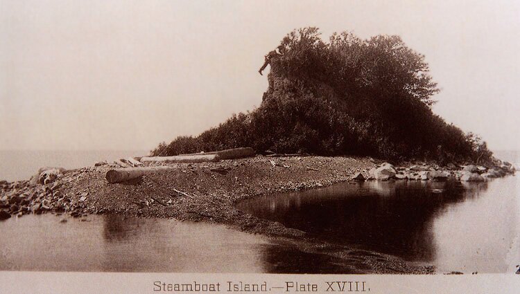
In the Wisconsin Historical Society's collection of historical maps, Asaph Whittlesey's legendary 1871 map of the Apostle Islands area has been finally made available here. Each island is shown with its name and acreage. Instead of the expected "Little Steamboat Island," our island is given the name "Chapman Island" – most likely named after its owner as we see for some of the other Apostle Islands. An interesting old postcard with a small but high-resolution map of the Apostle Islands is reproduced here. Note the presence of two islands by the "Steamboat Island" label. Finer detail is shown here. Volume III of Geology of Wisconsin – Survey of 1873-1879 (published in 1880), lists Eagle and Steamboat Islands separately and also gives "Steamboat" as an alternate name for Eagle Island. Eagle is described as "only a few rods long, very level, and shows rock all around, overlaid by 2 to 3 feet of clay." Furthermore: "Steamboat Island is a small clay islet, lying a few hundred feet south of Eagle Island. Between the two lies a still smaller rocky islet, 5 feet high and 15 feet in diameter." Perhaps the last-named feature was an eroded sea stack that had once been joined with Steamboat as part of a larger Eagle Island a long time ago. In a museum or library (or on some historian's coffee table) one might come across a copy of Lake Superior Region – edited and illustrated by J. M. Turner. This rare book is filled with photographs and reminiscences by the author of many sites associated with Lake Superior including Profile Rock (seen here in Photo 11), a sea stack situated just off the north shore of Basswood Island. Profile Rock is associated with some interesting folklore and is now known as "Honeymoon Rock." A major surprise in reading this book was to find not only a few paragraphs (and a poem) about Steamboat Island but also its photograph as it stood in the Summer of 1888! Click on the image below for a larger view. Judging from the size of the individual scaling the summit (and hastening erosion), the elevation was approximately 20-25 feet above lake level at that time.
From J. M. Turner's description of the island: "This is the smallest of the Apostle Islands and unlike any of the rest it is composed entirely of red clay on a stratum of limestone pebbles. It is so small and standing alone as it does it would seem that one severe storm could wash it away. It is protected, however, by a wide pebbly beach on which the waves spend their fury before they reach the superstrata of clay." Steamboat Island bears a superficial resemblance to Gull Island which is described here; note the topography in the 2002 photo of the Gull Island light. The "limestone pebbles" in the above description by Turner of Steamboat Island were more likely guano-encrusted gravel, a feature generally noted by visitors to the bird-infested Gull Island. It is possible that the following mention of Steamboat Island actually represents Eagle Island, although the "Little" Steamboat Island would have been easier to embark upon. This excerpt from a letter dated July 29, 1893 is in the Lt. Gen. James C. Breckinridge Collection which is featured on the Marine Corps University site: "We had some very rough weather on the lake and I felt uneasy more than once. One night we made for Steamboat Island, to camp on it and after beating up to within a quarter of a mile we had to take down our sails and row up against the wind Fred and I each took an oar because one person cannot row a sailboat very well, and I tell you it was hard work. The reason of papas having the sails lowered was because it was nearly eleven o'clock, there was some sea, no moon, and some rocks. A man lost about 13,000 feet of lumber (logs) on the lake by . . . reason of a storm the other day. It broke his boom all to splinters." Steamboat Island would be obliterated by the storm-driven waves of Lake Superior within a decade. The Marine Record, Vol. 24 (August 8, 1901), gives the following brief statement: "Steamboat Island, one of the Apostle group, off Chequamegon Bay, Lake Superior, has disappeared. Before the last storm and from time immemorial it was a small island of sand and rock overgrown with trees. Now it has gone and a rocky reef several feet under water marks its place." A New York Times article on the demise of Steamboat Island is reproduced here. Note how the island's description changes from "a favorite place for tourists" to "a menace to navigation"!
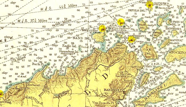
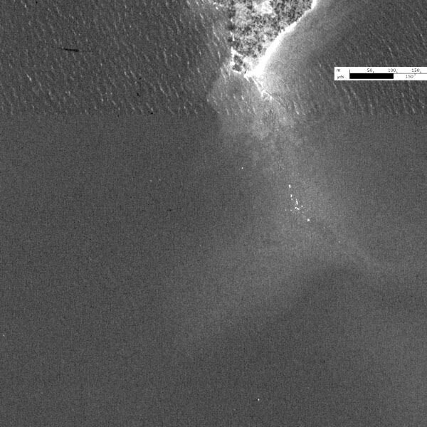
Official navigational charts which can be found on the Historical Map and Chart Project site show the location of the sunken island well into the 20th Century. (The map image on the right links to a larger portion of a 1919 nautical map from this site.) Modern-day aerial photographs on the Microsoft Research Maps site (formerly Terraserver-USA) – a composite of which is shown here (black bar represents 100 yards) – reveal some interesting submerged features around the southern edge of Eagle Island. These features suggest a greater land mass for this island in the distant past and include a shoal or reef at the likely site of Steamboat Island. A recent close-up photo of the southern tip of Eagle Island (seen here with other views of the island) shows the breaking off of a developing stack which may eventually separate and go the way of Steamboat Island. According to The Visitor's Guide to Apostle Islands National Lakeshore by Dave Strzok (privately published, 2003), the shoal south of Eagle Island does indeed represent the subject under consideration. This shoal is not to be confused with the considerably deeper "Eagle Island Shoals" which are found about a mile and a half to the south-southwest. So, that group of rocks seen about 300 yards south of the tip of Eagle Island in the aerial photo probably represents some visible evidence for the site of our micro-Atlantis. All of the various shallows among the Apostle Islands have been named except for this one, so one might think that Steamboat Island Reef (or Shoals) would be an appropriate and distinguishing designation. In the aerial photo, take a close look at the elevated lake bottom that radiates out in three directions, and then notice how Steamboat Island is situated in the Turner photo with a roughly triangular shape and an apparent sand bar tapering off at an angle in the foreground. As one goes back and forth between the two photos, one can see how the island might have fit into the surrounding area and almost imagine its reappearance during a period of extremely low lake level. Books indicated above are listed with additional information on our reference page. The Strzok and Ross books on this list tell some more stories about Steamboat Island, and Nuhfer gives a lot of information about the geology of the Eagle Island area. An ultra-tiny island formed off the shore of Madeline Island in the Spring of 2007 is shown becoming inundated here (Photo 15). |
|
The above note from The Marine Record is cited in the Great Lakes Historical Society's quarterly journal Inland Seas Vol. 15, No. 1 (Spring, 1959), page 54. Issues of Inland Seas are available on CD-ROM for the Lake history enthusiast who will also find the Great Lakes Shipping Downward Bound and Great Lakes Historical Society sites most interesting. Also, the Microsoft Research Maps site (formerly Terraserver-USA) has images courtesy of the USGS. |
||
|
Beware of web pages that "borrow" parts of this page and also confuse matters by connecting the site of Steamboat Island with the Eagle Island Shoals to the southwest, a major error this page was guilty of when first posted in 2004. |
||
|
|
The Steamboat Island Page – Version 5.6 |
|
 John L's Apostle Islands pages start