|
John L's Old Maps / Supplementary Pages: Evolution of Territories and States from the Old "Northwest Territory"
|
|
|
John L's Old Maps / Supplementary Pages: Evolution of Territories and States from the Old "Northwest Territory"
|
|
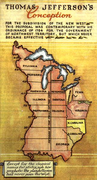
The Northwest Ordinance of 1787 set up the Northwest Territory, comprising an area including the present state of Ohio and extending westward and northward to the Mississippi River and present-day Canada. Various eastern states had made overlapping claims to this area including Virginia which designated the land "west of the Ohio" (probably at least A through P on the map shown below) as Illinois County from 1778 to '82, eventually relinquishing the claim in 1784. Thomas Jefferson's 1784 proposal for names of the states to be formed out of this area are listed here with an accompanying map. Click on image at right for another view which is taken from the "Historical Map of the Old Northwest Territory" produced by the Northwest Territory Celebration Commission of Minnesota in 1937.
Information for the tables and maps below is largely taken from the books edited by Long which are listed here.
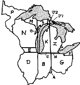
The following table and map show how divisions were made through 1818. (The letter "O" points to the eastern part of the peninsula extending into Lake Michigan.)
| 1787 | 1800 | 1803 | 1805 | 1809 | 1816 | 1818 |
Click here to view larger version of map in separate window. |
|
| Northwest Territory |
A-E G-P |
A F-J1 |
||||||
| Western Reserve (CT) |
F | |||||||
| Indiana Territory |
B-E J2-P |
A-E I-P |
A-B D-E L-P |
A-B L, O |
||||
| OHIO | F-H | F-G | F-G | F-G | F-G | |||
| Michigan Territory |
C H-K |
C H-K |
H-K | H-P | ||||
| Illinois Territory |
D-E M-N P |
D-E M-N P |
||||||
| INDIANA | A-C | A-C | ||||||
| Unorganized Territory |
L, O | |||||||
| ILLINOIS | D-E |
In the creation of the boundary between the Illinois and Indiana Territories in 1809, one might wonder if it was really the intent of those defining the boundaries to separate the distal end of what is now the Door County peninsula (the "O" region above) from Illinois Territory, rather than establish and maintain a contiguous governmental unit in that particular land mass. That is a problem with our trying to fit the occasionally faulty perceptions of the longitudes, latitudes and boundaries of two centuries ago onto our modern-day maps. At that time the longitude designated to define the boundary between these two territories may have been thought to be farther east of the mainland, and perhaps the examination of an Illinois Territory map of that era (something that could be linked from this website) would show no such division of the peninsula. On the other hand, these territories were meant to be temporary governmental units in an area not yet surveyed with the precision that would be required with the coming of statehood, so an element of arbitrariness could be expected.
Notice the straight-line, western boundary of "P" in the above map. The western boundary of the Northwest Territory (and of the United States in 1783) was originally meant to include a line drawn from the Lake of the Woods to the source of the Mississippi River. (Are there maps or documents that indicate the Lake of the Woods as the source of the river?) Although the source seems well-defined enough in the Farmer map of 1830 (shown on our first maps page in Map 3.1), it was not depicted with any precision until the Schoolcraft-Allen Expedition of 1832 (as shown here).
One may wonder about the significance of the "E" region. Officially it was always allied with "D" – a fact that was in dispute for many years. Occasionally, one hears this region referred to informally as "Baja Wisconsin"! Controversies about the boundary of Illinois are discussed here.
In Michigan Territory, the residents of the lower peninsula were eager to become a state and were apparently also eager to jettison the area west of the eastern end of the upper peninsula. Michigan Territory ultimately stretched to the Missouri River by the mid-1830s as shown in the next table.
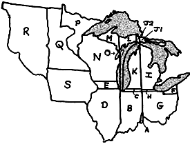
The next table includes areas beyond the original borders of the Northwest Territory which eventually became parts of certain territories and/or states formed from the Territory.
| 1834 | 1836 | 1837 | 1838 | 1846 | 1848 | 1849 | 1858 |
Click here to view larger version of map in separate window. |
|
| INDIANA | A-C | A-C | A-C | A-C | A-C | A-C | A-C | A-C | |
| ILLINOIS | D-E | D-E | D-E | D-E | D-E | D-E | D-E | D-E | |
| OHIO | F-G | F-G | F-H | F-H | F-H | F-H | F-H | F-H | |
| Michigan Territory |
H-S | H-M | |||||||
| Wisconsin Territory |
N-S | N-S | N-P | N-P | |||||
| De facto Wisconsin Territory |
P | ||||||||
| MICHIGAN | I-M | I-M | I-M | I-M | I-M | I-M | |||
| Iowa Territory |
Q-S | ||||||||
| IOWA | S | S | S | S | |||||
| Unorganized Federal Territory |
Q-R | Q-R | |||||||
| WISCONSIN | N-O | N-O | N-O | ||||||
| Minnesota Territory |
P-R | ||||||||
| MINNESOTA | P-Q | ||||||||
| "Unorganized Dakota" Territory |
R |
|
On a similar note, trace the Evolution of the American |
Information last modified on |
 Click on images for extended view in separate window.