AN ACCOUNT OF THE
Expedition Through Iowa Territory in 1844
by Captain James Allen and His Company of Dragoons

to follow the Des Moines River to its source and
to explore the general area to the east, west and south
 PLUS SOME INTRODUCTORY BIOGRAPHICAL DETAILS PLUS SOME INTRODUCTORY BIOGRAPHICAL DETAILS
Clicking on links to photos will open them up in separate window.
|
|
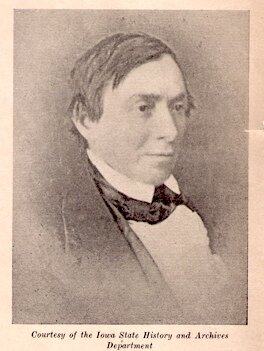
This is an authentic photo of James Allen which also appears on the Mormon Battalion Website Gallery. Previously shown here was a photo of a different James Allen of the U. S. Army.
|
House of Representatives Document No. 168 (1st Session of the 29th Congress) details an Army expedition led by Captain James Allen which covered 740 miles in the summer of 1844 – principally to reach the source of the Des Moines River and explore the area known today as southwest Minnesota and northwest Iowa.
In the following reproduction of the original report, all original spellings and punctuations have been maintained. The overall formatting has been generally followed, with extra spacing between journal entries and most other paragraphs. Of the two maps that are mentioned – i.e., the one prepared by Lt. Potter and the replacement based on the map of Nicollet – neither was included in or with the original report. Lt. Potter's map was eventually published in the Iowa Journal of History, Volume 51, No. 1 (January, 1953) along with an anonymously-written journal of the same expedition which is reproduced here. (Beware: CD copies of the Iowa Journal of History may not include maps.) My insertions are in brackets with my initials (JL).
As originally printed by Ritchie & Heiss, the report was printed on a few large, untrimmed sheets which were folded over to produce a booklet with a small, knotted string as the single "binding." It was up to the reader to slice along the folds to separate the pages and finally produce a "normal" booklet.
The expedition was apparently well-provisioned, and the participants were also able to partake of the abundant game available. Somehow, reliable equipment for fixing geographical position was not provided for. However, it is remarkable how the distances covered could be determined with such apparent confidence.
Following is a list of some biographical details about Captain Allen gathered from various exploits mentioned on the web and found scattered here and there while perusing bookstores and libraries. His story is yet to be told in a comprehensive biographical volume, and there is enough adventure and pathos to make an exciting true-to-history movie. At least through 2010, next to nothing of his fixing geographically the source of the Mississippi River can be found in historical displays at the Itasca State Park which otherwise feature his partner, Henry Schoolcraft. That is like telling the story of Lewis and Clark – without mention of Clark.
- February 15, 1806. Born of Irish parents in Ohio.
- 1825. Entered the Military Academy at West Point as a cadet from the State of Indiana.
- 1829. Graduated from West Point – 35th in a class of 46. A fellow classmate was Robert E. Lee. Assigned to duty as Second Lieutenant at Fort Brady, Sault Ste. Marie, Michigan Territory.
- 1832. Ordered to head a military escort for Henry Schoolcraft on an expedition to visit and vaccinate the Indians in west-central Michigan Territory which, at the time, reached to the Missouri River – well into what is now the Dakotas. While on this expedition, Allen produced the first correct map establishing the exact position and direction of the Mississippi River as it exits Lake Itasca, which in turn collects the water from the streams and springs in the large Itasca basin. On the return journey, the military escort fell behind and suffered numerous hardships along the St. Croix and Brule Rivers.
Journals and reports of this expedition are included in the references listed here and include Allen's official report which is freely downloadable here. His Journal entry which details the expedition's visit of July 13, 1832 to Lake Itasca is here, and his map of the St. Croix/Brule portage area is shown here as Map 4.1.
- 1833. Attached to the First Regiment of Dragoons near St. Louis. Later transferred to Fort Leavenworth in Kansas and promoted to First Lieutenant. Served as an engineer in the exploration of the Indian country of the Southwest.
- 1834. Took charge of improvements to the Chicago harbor. Subsequently a steamer was built and named after him in 1838.
- 1837. Conducted a survey in the summer for the establishment of a harbor at Kenosha, Wisconsin. (This according to "Early History of Kenosha" by M. Frank, Wisconsin Historical Collections, Volume iii (1904), p. 388.)
- 1837. Promoted to Captain and given command of Company I, First United States Dragoons.
- 1842. Assigned to supervise the Sac and Fox Agency (named "Fort Sanford" by Allen) near the present site of Ottumwa, Iowa.
- 1843. Established and commanded Fort Des Moines on the Des Moines River at the mouth of the Raccoon River. The fort was necessary to protect the Sac and Fox from continuous, aggressive intrusions by settlers, traders and the Sioux. The city of Des Moines was established on this site after the dissolution of Fort Des Moines in early 1846.
- 1846. In July, enlisted over 500 Mormon men in Council Bluffs, Iowa for an expedition to California to provide a reserve force in the Mexican War which became known as the "Mormon Battalion." This expedition was basically intended to facilitate the Mormons' westward migration. There is much on the web that tells of Allen's organization and command of the Mormon Battalion, and a Google search can be quite productive. A notable page can be found here.
- August 23, 1846. Allen, by now promoted to Lieutenant Colonel, died en route at Fort Leavenworth and was buried that day at the Fort Leavenworth National Cemetery.
A Wikipedia article on James Allen has appeared and can be read here.
Here is an excerpt from Allen's Journal entry of July 13, 1832 – the day the Schoolcraft-Allen Expedition came upon what was to become known as Lake Itasca, the source lake of the Mississippi River.
|
From these hills, which were seldom more than two or three hundred feet high, we came suddenly down to the lake, and we embarked and passed nearly through it to an island, near its west end, where we remained one or two hours. We were now sure that we had reached the true source of the great river, and a feeling of great satisfaction was manifested by all the party; Mr. Schoolcraft hoisted a flag on a high staff, on the island, and left it flying. . .There can be no doubt but that this is the true source and fountain of the longest and largest branch of the Mississippi. All our information that we had been able to collect on the way, from traders and Indians, pointed to it as such; and our principal Indian guide, Yellow Head, who has proved to us his close intelligence of the country, represents the same. . .It will be seen, from my map, that Lac La Biche is but little west of south from Cass lake, and almost due south from Lac Travers, which is a different position from that assigned to it on published maps, where it is invariably represented north of Cass lake.
|
During or (more likely) following the 1832 Expedition – as recounted in Henry Schoolcraft's Summary Narrative of an Exploratory Expedition to the Sources of the Mississippi River (published in 1855 by Lippincott, Grambo and Co., Philadelphia) – the author named a tributary of the Mississippi after Allen. From Schoolcraft's description of the location, this stream is quite possibly the outlet of Lake Manomin which is also known as Rice Lake and is in turn fed by the Little Mississippi River and Grant Creek.
|
This stream, for which I heard no name, I designated Allenoga, putting the Iroquois local terminal in oga to the name of the worthy officer who traced out the first true map of the actual sources of the Mississippi.
|
From the journal written by Dr. Douglas Houghton during this expedition (reproduced in the Mason book cited here):
|
July 4th. Wednesday. . .Lieut. Allen celebrated the anniversary of our independance by inspecting his soldiers and firing 24 rounds of cartridges [one for each state, as indicated by Rev. William Boutwell in his journal]. The dread in which the Indians hold soldiery is truly astonishing. They consider them as men who have sold themselves to die & are consequently afraid of nothing.
|
The following is excerpted from a brief biography of James Allen found in Iowa – Its History and Its Foremost Citizens by Johnson Brigham (published in 1918 by the S. J. Clarke Publishing Company, Chicago):
|
James Allen, founder of Fort Des Moines, was not the typical soldier of old romance. He valued "the bubble reputation" at its real worth. Free from Cromwellian ambition, he escaped "fame's damnation." The plaudits of unborn ages never confused his view of present duty. He left no track of light for men to wonder at. He chose a soldier's life and uncomplainingly lived that life. With soldierly equanimity, he accepted new situations, not quarreling with fate, and standing well with the Department. Without compromising his dignity or yielding one jot of authority vested in him by his Government he won the respect and love of his men. When he died, many tears were shed, and long after his death his name was mentioned reverently and lovingly, even by men of an alien faith. Such a man, with whose name must ever be coupled the development of interior Iowa and the founding of the State, is surely worthy to be memorialized.
|
|
CAPTAIN J. ALLEN'S EXPEDITION.
LETTER
FROM
THE SECRETARY OF WAR,
TRANSMITTING
The report, journal, and map of Captain J. Allen, of the first regiment of dragoons, of his expedition of the heads of the rivers Des Moines, Blue Earth, &c., in the northwest, in compliance with a resolution of the House of Representatives of the 29th of January, 1845.
MARCH 20, 1846.
Read, and referred to the Committee on Military Affairs.
WAR DEPARTMENT, March 19, 1846.
SIR: In further answer to a resolution of the House of Representatives, passed the 29th of January, 1845, requiring the Secretary of War to communicate to the House "a copy of the report, journal, and map of Captain J. Allen, of the first regiment of dragoons, of his expedition during the past summer to the heads of the rivers Des Moines, Blue Earth, &c., in the northwest," I respectfully transmit herewith a communication from the Adjutant General of the army, enclosing the report in question, which has just reached this department.
Very respectfully, your obedient servant,
W. L. MARCY,
Secretary of War.
Hon. JOHN W. DAVIS,
Speaker of the House of Representatives.
ADJUTANT GENERAL'S OFFICE,
Washington, March 18, 1846.
SIR: The report of Captain J. Allen, 1st dragoons, of his expedition during the summer of 1844, was received too late to comply with the resolution of the House of Representatives of January 29, 1845, before the rising of the 28th Congress; and, understanding that the mover of the resolution (a member of the present Congress) is desirous that the resolution should now be complied with, I accordingly, in compliance with your instructions, furnish a copy of the report called for by the resolution above mentioned. Instead of the map of the route accompanying the report, I submit the more perfect map of the Upper Mississippi by Nicollet, (from which Captain Allen's sketch no doubt was taken,) upon which the route of the troops under his command has been carefully traced, in red lines, in the topographical bureau.
Should it be determined to publish Captain Allen's route, Colonel Abert is of opinion it would be best to use the plate prepared for Nicollet's map. This mode would be not only much less expensive, but would probably improve the original map, which is one of much value.
I am, sir, very respectfully, your obedient servant,
R. JONES, Adjutant General.
Hon. W. L. MARCY,
Secretary of War.
Report of an expedition into the Indian country, made by company "I," 1st regiment of dragoons, in obedience to orders No. 13, dated headquarters third military department, St. Louis, Mo., June 13, 1844.
The company was organized for this expedition in the early part of July, but was detained by subsequent orders until the 11th of August. It marched from Fort Des Moines with the following strength:
Captain J. Allen, 1st dragoons, commanding;
Assistant Surgeon J. S. Griffin, medical staff;
First Lieutenant P. Calhoun, 2d dragoons;
Second Lieutenant P. Noble, 1st dragoons;
Brevet Second Lieutenant J. H. Potter, 1st infantry, A. C. S., and A. A. Q. M.;
50 rank and file of dragoons; and
2 privates of infantry.
The troops were provisioned with pork for 40 days, flour for 60 days, and small rations for 70 days. The route designated in the department orders referred to was up the Des Moines river, and to the sources of the Blue Earth river of the St. Peter's [i.e., the Minnesota River as it is known today (JL)]; thence to the waters of the Missouri; and thence returning through the country of the Pottowatomies. So little was known of the true geography of the country to be passed over, that it was impossible to define the route beforehand with minute exactness; and I was of course embarrassed in some degree, to estimate the time we ought to be out, and the distance we might have to march. I therefore made provision for a march of about 800 miles, and an absence of 70 or 80 days, assuming that many days might be employed in exploring the country near the line of our route. For the actual route passed over, I must refer to the accompanying map, which will show it more fully and completely than it could be made by any other description. The map was constructed by Lieutenant Potter, under my immediate direction, and the care of taking minute notes on the way, and the pains taken during its projection by that officer to secure all the information within his reach, will warrant me in saying that it gives a very correct delineation of the country passed over, as also the topography of other parts of this territory perhaps the most accurate on record.
For a minute description of the country, and a close relation of all matters connected with the march, I will refer to the accompanying journal, which gives the observations of each day, and is nearly a literal copy of my notes made at the time shown by the record.
The route was from this post up the Des Moines river on the west side, as far as the "Iron Banks," when we crossed that river a few miles above its forks, and 100 miles above the mouth of Raccoon; thence up between the forks, but near the west branch, to the extreme source of this branch, in a lake which I have named "the Lake of the Oaks," 248 miles from the mouth of Raccoon. This lake may be taken as the true source of the Des Moines river, being at the most northerly point of any of its waters, and the furthest from its mouth.
[The "Lake of the Oaks" noted here and described in the journal below appears to match up with Lake Shetek in southwestern Minnesota – a lake already familiar to natives and explorers and described by Joseph Nicollet by that name in the journal of his travels through the area in 1838. In all fairness to Capt. Allen, Nicollet's final report with the fully-annotated map may not have been available by the time of Allen's expedition. Nicollet not only described the Des Moines River as flowing from the lake, but he also indicated streams flowing in, the longest of which can be seen on today's topographical maps as arising near Balaton, Minnesota. (JL)]
It is otherwise remarkable for a singular arrangement of peninsulas, running into it from all sides, and for a heavy growth of timber that covers these peninsulas and the borders of the lake. We found its latitude, by several observations of the sun, to be 43° 57' 32"; but the observations were made with a small and imperfect sextant, and ought not to be assumed as entirely correct. We had no means of determining its longitude, as we could not with our instruments measure even lunar distances, and we were not supplied with a chronometer.
From the Lake of the Oaks, I explored the country north 37 miles to latitude 44° 27' 32", and thence east to the St. Peter's river, in the same latitude.
In this route I crossed twice going out, and once returning, a small stream bearing to the south, and which I took to be a branch of the Blue Earth river; and, if so, it is the most northerly branch of that river. From the St. Peter's river, I made a circuit to the southward of 57 miles, to return to the Lake of the Oaks, where a portion of the command had remained encamped. Thence I marched nearly due west 38 miles to a river which I took to be the Big Sioux of the Missouri. We followed this river down 159 miles to its mouth in the Missouri river, and thence took the nearest practicable route back to Fort Des Moines, crossing on the way the Little Sioux river, and several minor streams noted on the map. The features of the country from Fort Des Moines to the upper forks of the Des Moines river are much the same as those of the country bordering this beautiful river belowelevated rich prairie, broken by points of timber, and well timbered ravines extending into it from the river every few miles. The valley of the river often expands to make bottoms, sometimes prairie and sometimes timber, of one, two, and three miles in breadth, and always of the richest quality of soil. The timber of the Des Moines for this distance is fully equal to the wants of its share of the prairie dividing it from other streams, and will easily supply all of the farms that may be made tributary to the river. After passing the "Iron Banks," the timber falls off very much. The groves are almost all confined to the immediate valley of the stream, are narrowed in width, and frequently the bare prairie borders both sides. The first twenty miles of prairie is elevated, rolling and dry; the soil is sandy, and much mixed with pebbles and small fragments of lime and primitive rock. Then comes a series of lakes, many of them connected by slues and straits to form chains, almost impossible to go around or to cross, and extending from the Des Moines to the northward and eastward. This kind of country continues on the river about 35 miles, giving the greatest embarrassment to the traveller, who must frequently betake himself to a raft or ponton wagon to make his progress through it. After this comes a dry country again, very hilly and broken near the river, and back from the river dotted with numerous little lakes that have no connexion, outlet or inlet. Here there is no timber except a narrow skirting of a few trees at points along the river or on the borders of the lakes, and occasionally a pretty grove in a bend of the river or a peninsula of a lake. There is not for 70 or 80 miles below the source of the Des Moines enough of timber to supply a single row of farms along its border. At the Lake of the Oaks there are many hundred acres of excellent timber; but the country all around it is high and bleak, and looks so inhospitable that it will be many years before any settlement can be led to it. From this point north and east to the St. Peter's, 50 or 60 miles, there is much fine rich prairie, covered with a luxuriant grass, easy to march over in any direction, but no timber to speak of. Much the same kind of surface extends west from the source of the Des Moines to the Big Sioux river of the Missouri. And here was the first great buffalo range that we had seenand surely, of all this upper country, these animals could not have selected any more rich, luxuriant, and beautiful for their summer feeding. All of the country from the St. Peter's river to the Big Sioux, in latitude from 43° to 44 1/2°, may be easily traversed by troops, but the commander of a column must not march widely from the timber of the streams and lakes, else he will find himself often encamped without fuel to cook his provisions. The grass is rich and abundant in its season, and the surface is well adapted to the operations of cavalry.
We came to the Big Sioux on the 10th of September, in latitude nearly 44°, and here saw the first Sioux Indians. There were some 20 or 30 of them; and they were much alarmed at seeing us in their country: (see my journal of this date.) They were otherwise careless in every respect, and seemed to be moving along with the buffalo as they were all the same people. When we struck this river, it looked large enough to have its source 70 or 80 miles above. The general course of the river from here to its mouth (159 miles) is nearly due south, and it seemed to run all the way in a gentle current of two miles per hour, except at the falls described in my journal, where it breaks through a wonderful formation of massive quartz that crosses it perpendicularly, and over which the river falls 100 feet in 400 yards. The valley of the river is seldom more than a mile broad, but is all of the way of the richest soil resembling the alluvions of the Missouri. There is but little timber on any part of itnot enough to authorize a full settlement of the valley proper. The general level of the country back is from 300 to 500 feet above the bed of the river; and it falls off to the valley generally in gentle slopes, until within fifty miles of the Missouri when the country becomes exceedingly broken, from six to twelve miles back and the bluffs near the river are frightfully steep, and cannot be crossed anywhere without the greatest difficulty.
Leaving the ugly hills of the Missouri about the mouth of the Big Sioux, and going east, we find a gently undulating surface of country, and cross successively Floyd river, the Little Sioux, and Soldier's river. The Little Sioux is much the largest of these, and is probably more than 100 miles long. All three of these streams are slightly skirted with good timber, but there is none anywhere between them. The prairie is everywhere of the richest soil, except at the crossing of many little deep brooks, with muddy banks, that seldom show timber enough to make bridges over them. Pottowatomies consider the Little Sioux as the northern boundary of their lands, and make great hunts along its course every year, killing elk, deer, and bears. From the waters of the Missouri, we next come in about 30 miles to the upper branches of the Raccoon. Approaching these branches the prairie is flat and wet; and much filled up with marshes and grassy ponds, through which it is difficult to find a practicable route.
After crossing the Raccoon, the country between it and other tributaries of the Des Moines is rolling, dry, and rich, and easy to march over. The Raccoon is about 100 miles long, and runs all the way in a deep narrow valley clothed with the richest of timber. This river is one of the most beautiful of the territory, and will soon induce settlement and cultivation of its borders along its whole length.
From Lizard creek of the Des Moines to the source of the Des Moines, and thence east to the St. Peter's, is a range for elk and common deer, but principally elk. We saw a great many of the elk on our route, and killed many of them; they were sometimes seen in droves of hundreds, but were always difficult to approach, and very difficult to overtake in chase, except with a fleet horse and over good ground. No dependence could be placed upon this game in this country for the subsistence of troops marching through it.
Twenty-five miles west of the source of the Des Moines we struck the range of the buffalo, and continued in it to the Big Sioux river, and down that river about 86 miles. Below that we could not see any recent sign of them. We found antelope in the same range with the buffalo, but no elk, and very seldom a common deer. While among the buffalo, we killed as many as we wanted, and without trouble.
The geological features of the route are sufficiently noticed in my journal, and nothing very remarkable on this subject was presented.
The only rocks seen in place were, first, a limestone ledge, forming one bank of the Des Moines at the "Iron Banks," where we crossed that river; second, the great bed of granite in the valley of the St. Peter's; and, third, the massive quartz at the falls of the Big Sioux.
I was surprised at meeting with more Sioux Indians. We penetrated their country very far, saw numerous trails and other signs of them, but only came actually in contact with two small roving parties on the Big Sioux; and we came upon these so suddenly that they were forced to meet us. They were much alarmed; approached us with great timidity, and, notwithstanding our assurances of friendship, seemed to wish to get rid of us as soon as possible. They told us there was a trading house down the Big Sioux, where there were also thirty-six lodges of Sioux Indians, all of which was entirely false, as we afterwards ascertained. We must have been seen frequently by other parties of these Indians, who did not wish to meet us; on one occasion two or three Indians were seen watching us from a distance.
This expedition, together with the almost simultaneous one made by Captain Sumner's company from Fort Atkinson, near the valley of the St. Peter's, and to the north of it, must have produced a great moral effect upon these wild Indians, as showing them conclusively that we can easily throw cavalry enough into the heart of their country to chastise them for any wrong they may do to our people and government.
In regard to the information requested of me by Captain Cram, of Topographical Engineers, in his letter to Colonel Kearney, dated St. Louis, July 25, 1844, on the subject of the extraordinary floods of last summer of the Mississippi and its tributaries, as connected with the subject of alluvial formations, I regret that, for want of time and proper means necessary for making the nice observations necessary to a close investigation of this matter, I will not be able to furnish all the information anticipated and politely desired by Captain Cram.
I furnish, however, with cheerfulness, all of my observations on this subject that I think of any use. The Des Moines river, at the mouth of Raccoon river, rose 13 1/2 feet above its common stage; but it was at this point, and generally above, confined within its proper banks. It did not overflow any of its prairie bottoms, as far as I have observed, up to its extreme source. Its timbered bottoms, being generally lower than the prairie, were, many of them, covered from one to three feet. The earthy deposite in the timbered bottoms varied with the depth of the overflow, and would not anywhere exceed a half inch in thickness for three feet of overflow. This river, which I traced up carefully to its source, seemed to have risen in proportion to its volume or breadth all the way up.
Thus at the Iron Banks, 100 miles above Raccoon, it had risen 10 1/2 feet, and 100 miles further up it had risen 7 feet; but this river has but few tributaries above Raccoon, and drains a country only extensive in length. It is generally broad and shallow, and much of the country along it being flat and marshy and slow to draw off, it may never rise in height like some other streams of lesser magnitude. The next stream to notice was a small branch of the Blue Earth river, which we crossed in latitude 44 1/2°. This little stream, not more than 20 feet broad and 2 feet deep, had risen out of its banks, which were 8 feet high, and had uprooted willows and shrubs along its borders which had been the growth of years, and deposited them on points projecting into its general course. I observed the same appearance on other little streams in this latitude, and inferred that they had all been much higher this year than for many years previous. When we saw Little St. Peter's in latitude 44 1/2°, it also showed signs of an extraordinary rise. It had overflown all of its proper bottoms, and I noticed a deposite of vegetable debris half a mile from its bank, and about 30 feet above its ordinary level. This river, where we saw it, was narrow and swift for its quantity of water, and had scarcely any low bottoms for the expansion of its waters at times of high floods. Here it has broken through an immense formation of granite rock, and deposited great masses and fragments of this rock in its valley for many miles below: (see my journal.)
The next river to be noted is the Big Sioux, which we first touched 38 miles east [actually west (JL)] of the source of the Des Moines, and in latitude about half a degree below our point on the St. Peter's. It had risen about 17 feet, covering all of its bottom lands five or six feet. Great masses of drift wood had been deposited on its low grounds and timbered bottoms, but I saw no earthy deposite worthy of note. We followed this river down 159 miles to its mouth, and the rise had been everywhere greater as the stream increased in size. Near its mouth it had partaken of the great rise of the Missouri. And here I noticed water-marks four miles from the Missouri, which I estimated to be at least 25 feet above the ordinary level of that river. The Missouri had been over all of its valley by a great depth; but seeing it only at and near the mouth of the Big Sioux, I did not observe deposites of alluvion worthy of note.
From the mouth of the Sioux to the Raccoon, the streams had all overflown their banks, but had deposited nothing of consequence but drift wood and weeds. The Raccoon had been unusually high everywhere; all of its woodland bottoms were filled with drift wood timber and other vegetable debris, until within 20 or 30 miles of its mouth; after which it appeared, like the Des Moines, to have been confined to its immediate banks. The country of the whole route passed over showed everywhere traces of wonderful rains, and from all that I could observe I am of opinion that the greatest rains occurred above any latitude that we penetrated.
If my journal can give Captain Cram any further information than is here detailed, on the subject of his letter, and which he has politely requested for a most meritorious object, I hope the colonel commanding the department will place it at his service.
FORT DES MOINES, IOWA TERRITORY, January 4, 1845.
J. ALLEN,
Captain, 1st Dragoons.
Colonel S. W. KEARNEY,
Comm'g third military department U. S. army, St. Louis, Mo.
|
This report continues in "Part 2" with Captain Allen's daily journal.
On yet another page of this site is a comparison of his journal with one written by an anonymous participant of the expedition.
|
Page last modified on 3/26/12 at 2:00 PM, CDT with the
authenticated photo of Captain Allen. (Thank you, Kevin!)
John Lindquist: homepage & e-mail, site outline.
Department of Bacteriology, U.W.-Madison
|