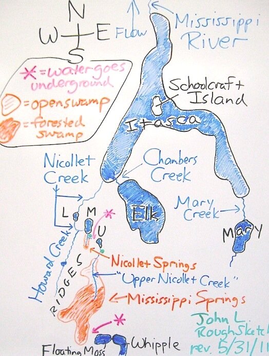
A Rough Sketch of the "Headwaters" to Accompany the Video "Visiting a Source of the Mississippi River" First of all, consider that the water that seeps or flows into Lake Itasca is travelling from south to north, and the Mississippi River escapes at the north end of the lake. Eventually it makes a wide arc eastward and then southward – and then onward to the Gulf of Mexico. To give some perspective to this sketch map, Whipple Lake is approximately 2 miles from Lake Itasca, and the western side of the lake is approximately 3 miles from the mouth of Nicollet Creek to the start of the Mississippi. (These distances are as the ravens fly. The convolutions of the streams may double their lengths.) The small area covered in the video is between the green dots. At the end of the video, the water continues to make its way uninterrupted to the Gulf. In the 1830's, the explorer Jean Nicollet considered Whipple Lake as the beginning of the Mississippi River. This lake is fed by springs from the hills, and the outlet flows northward toward Lake Itasca. However, as made known in publications by Brower (in the 1890s), there is not an open channel over the entire two-mile distance. This is due to a couple places where the water pools up, travels underground and then comes up as springs. These "disconnects" are pointed out on the map with red asterisks. Three lakes along the way were noted by Nicollet in his Official Report, and – as Brower didn't think Nicollet had gone all the way to Whipple Lake – he came to his conclusion that the three lakes were those which are labeled U, M and L (for upper, middle and lower) on the map. But, according to the more-recently published Journals, Nicollet had Whipple Lake as his first (upper) lake and "M" (called Nicollet Lake presently) as his third (lower) lake. It is possible that his second (middle) lake is presently represented by the swamp associated with the "Mississippi Springs" wherein a beaver dam at its downstream end could raise the water level considerably. What I have labeled as "Upper Nicollet Creek" was designated by Brower as the "Detached Upper Fork of the Mississippi River"! Nicollet called it "the infant Mississippi," describing it as "a cradled Hercules." My four-page site starts here and covers the area more thoroughly with photos and links to videos. John Lindquist |
 Click on image for full view in separate window.